Submeter GPS Under Tree Cover With 15 Minute Occupations
Research backed practitioner guide to reliable GPS under tree cover. When to use 15 minute occupations, multiband receivers, PPK/RTK, or sensor fusion.
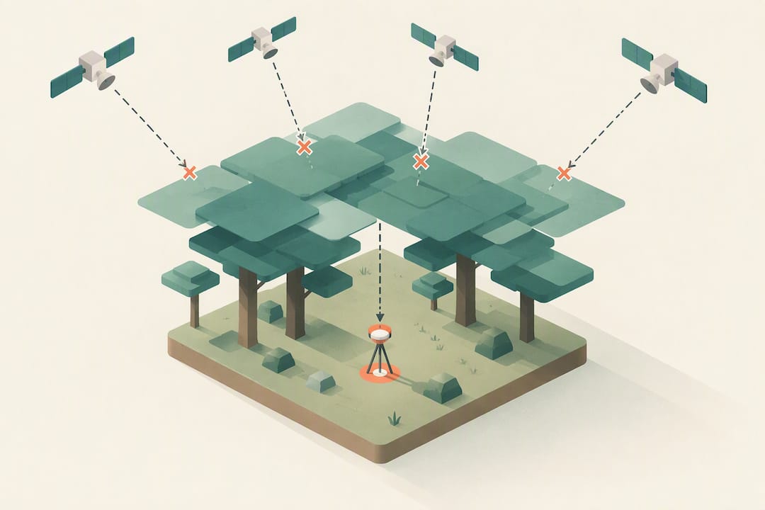
Submeter GPS Under Tree Cover With 15 Minute Occupations
GPS and GNSS can be trusted for casual navigation under tree cover, with errors typically landing in the single-digit to low double-digit meters. For survey-grade work, the single biggest improvement is switching to a multi-band, multi-constellation receiver and running longer occupations or post-processed corrections. Whatever device you carry, always bring a map-and-compass backup.
TL;DR:
- Under dense tree cover, GPS errors typically range from a few meters to over ten meters, depending on conditions and equipment quality.
- Multipath signals caused by bouncing off branches and trunks are the dominant source of inaccuracy rather than signal blockages alone.
- Multi-band, multi-constellation receivers significantly improve accuracy and recovery time when working under canopy, especially if paired with longer occupation times or post-processing.
- External, high-mounted antennas and choke-ring styles can reduce multipath reflections, improving fix reliability in forest environments.
- Combining GNSS with inertial sensors or visual SLAM systems enhances positional accuracy and continuity during prolonged satellite outages.
Kinwatchdog
Stay Connected Beyond the Trail
Kin One helps families monitor kids, pets, and parents on one map, with real-time updates and no monthly fees.
Table of Contents
- Why tree canopy breaks your GPS fix
- How accurate is GPS really under trees?
- Which upgrades actually move the needle
- A field checklist for reliable readings under canopy
- When sensor fusion beats GNSS alone
- Choosing between accuracy, speed, and cost
- Keeping track of family and pets near wooded areas
- FAQ
- Sources
Why tree canopy breaks your GPS fix
Three separate problems degrade positioning under trees, and they behave differently.
Blockage happens when a trunk or branch sits directly between your receiver and a satellite, killing that signal entirely. Attenuation is softer: leaves and wood absorb and scatter energy, weakening a signal without fully blocking it. Multipath is the trickiest, since a signal bounces off a branch or trunk and arrives late, confusing the receiver’s distance calculation. A controlled forest study comparing smartphone, Garmin, and Trimble receivers found that nearby tree arrangement correlated with horizontal error, and that multipath, not atmospheric delay, was the dominant error source.
The carrier-to-noise ratio (C/N0) is your best real-time diagnostic. A healthy open-sky signal might sit well above 40 dB-Hz, while a signal struggling through foliage can drop into the 20s or lower, a range where fixes become unreliable or drop out.
- Blockage removes a satellite from the solution entirely, shrinking your geometry.
- Attenuation weakens otherwise usable signals and slows time-to-fix.
- Multipath introduces false ranges that can look like a valid fix while being wrong.
Leaf-on canopy attenuates far more than leaf-off, so the same trail can perform noticeably differently between winter and summer.
How accurate is GPS really under trees?
Accuracy under canopy spans a wide range depending on receiver class and how long you’re willing to wait for a fix.
Submeter horizontal accuracy is achievable under closed-canopy conifer forest, according to a USFS Pacific Northwest study, but only with survey-grade receivers, occupations of 15 minutes or longer, and proper post-processing. Short, quick fixes rarely reach that level.
Consumer and mapping-grade units generally land in the meters-to-tens-of-meters range under heavy canopy, and the gap closes somewhat as occupation time increases. Receiver height above ground, antenna exposure to open sky, and distance from a base station or correction source all shift this range, sometimes dramatically.
The same research found that on-device accuracy estimators, the number flashing on your handheld screen, routinely underestimate true error in forest settings. Repeat-occupation testing and comparison against known reference points correlate far better with benchmark geodetic results than a single reported value ever does.
Which upgrades actually move the needle
Not every upgrade pays off equally once you’re under a canopy. Multi-band, multi-constellation receivers (tracking GPS, Galileo, GLONASS, and BeiDou across L1 and L5 bands) give you more visible satellites at any moment, which matters enormously when trunks and branches are constantly blocking individual signals. More satellites means better geometry and faster recovery after a dropout.
Corrections are the second lever. RTK delivers real-time centimeter-to-meter accuracy but depends on a steady radio or cellular link to a base station, a link that itself struggles under dense stands. PPK sidesteps that problem by logging raw data in the field and correcting it afterward against a reference station, trading immediacy for reliability. PPP sits between the two, using satellite-based corrections without a local base but generally needing longer convergence times.
Antenna choice matters more than most people expect:
- An external antenna mounted higher than a handheld’s internal one reduces ground and canopy multipath.
- Choke-ring style antennas suppress low-angle multipath reflections that are common near trunks.
- A 2024 RTK evaluation in forested plots recorded RMSE around 2.03 meters for short 30-second observations, with coniferous and deciduous plots performing differently, underscoring how much forest type matters.
Pro Tip: Before trusting a short RTK fix under canopy, check the quality indicator on your receiver rather than the position estimate alone; a low fix-quality flag means the number on screen may be meaningless.
A field checklist for reliable readings under canopy
Preparation before you ever step under the trees determines most of your result.
- Choose a multi-band receiver when the task allows it, since multi-constellation tracking recovers faster from blockage.
- Confirm whether real-time corrections (cellular or radio RTK) will reach your site, or plan for PPK logging instead.
- Decide your occupation length in advance: brief readings for casual waypoints, 15 minutes or more for anything that needs to hold up later.
- Identify a fallback method (compass bearing, known landmarks, flagged tape) before you lose signal, not after.
In the field, raise your antenna above your own body and as far from trunks as practical, since a few extra feet of clearance can mean several more visible satellites. Work during brief openings in canopy, like small clearings or deciduous stands in leaf-off season, when possible. Repeat critical observations rather than trusting a single fix, and physically mark points you intend to revisit with flagging or stakes so you can relocate them even if the electronic record is uncertain.
When GNSS becomes unreliable, fall back deliberately rather than guessing. Map-and-compass navigation remains the most dependable zero-electronics option. IMU-assisted handhelds can bridge short outages through dead reckoning. For points that matter, mark physical monumentation on the ground so a later PPK pass or a return visit under better conditions can still recover accurate coordinates.
Pro Tip: Log your raw observation file even when you only need a real-time fix: a few extra minutes of logging costs nothing and gives you the option to post-process later if the live result looks shaky.
When sensor fusion beats GNSS alone
For continuous navigation rather than single-point surveying, combining GNSS with other sensors often outperforms GNSS by itself in deep canopy.
- IMU and GNSS fusion lets a device dead-reckon through short signal gaps using accelerometer and gyroscope data, smoothing over the moments when satellites disappear.
- Visual-inertial SLAM, drawn from robotics research, builds a local map from camera and motion data so a system can keep tracking position without relying on satellites at all; robotic navigation experiments in dense forest have demonstrated this approach for mapping and movement where line-of-sight to satellites is routinely blocked.
- LiDAR-based SLAM extends this further for research platforms and some professional equipment, though it adds weight and cost that most field teams don’t need.
For a weekend hiker or a single property survey, standard GNSS protocols with patience and redundancy are enough. Sensor-fusion hardware earns its cost when outages are frequent, prolonged, or safety-critical, such as search-and-rescue work or long traverses through continuous closed canopy.
Choosing between accuracy, speed, and cost
The honest answer is that no single workflow wins every time, so plan for redundancy instead of a perfect device. Verify any point that actually matters with a repeat observation or a second method, because a single fix under trees is a guess dressed up as a number.
For most people, a multi-band receiver is the highest-value single purchase. Reserve RTK or PPK for tasks that genuinely demand survey-grade certainty, and test your workflow in conditions similar to your real site before you depend on it.
— Louis
Keeping track of family and pets near wooded areas
A backyard survey and a quick check on where your kid or dog wandered off to are completely different problems, and they call for different tools. For the second one, we built Kin One as a one-time-purchase GPS tracker: $99 once, no monthly fees, with live location updates for kids, pets, and parents all on a single map.
We want to be straightforward about what that device is for. A consumer tracker like Kin One gives you situational awareness: where someone is right now, whether they’ve arrived or left a place, a general sense of movement through the day. It is not a substitute for survey-grade positioning, and under thick, continuous canopy any consumer GPS device, ours included, will see its accuracy soften the way the research above describes.
If your family spends time in wooded parks, campgrounds, or trail systems, we’d encourage testing a tracker in those exact conditions before relying on it for anything time-sensitive. Check specs and order on our Kin One product page.
FAQ
What does Russia use instead of GPS?
Russia operates its own satellite navigation system called GLONASS, which functions on the same basic GNSS principles as the American GPS constellation. Many modern multi-constellation receivers track both systems simultaneously, which is part of why multi-constellation devices tend to perform better under tree cover than GPS-only units.
Can I survey my own property with GPS?
You can collect GPS points on your own property for personal reference, but boundary-line surveys intended for legal purposes generally require a licensed surveyor using survey-grade equipment and proper protocols. Under tree cover specifically, a USFS study found that even submeter accuracy needs 15-plus minute occupations with survey-grade receivers, a standard that casual consumer devices don’t meet.
What is replacing GPS?
Nothing is replacing GPS outright, but research increasingly pairs it with other sensing methods for places where satellites alone fall short. Visual-inertial SLAM and IMU-based dead reckoning, both used in robotic forest navigation research, let systems keep tracking position through gaps in satellite coverage rather than depending on GNSS exclusively.
What is the best GPS for walking in the woods?
For casual trail navigation, a handheld or smartphone-based multi-constellation GPS unit is generally sufficient, since the goal is staying oriented rather than achieving survey precision. For tracking where family members or pets are relative to trails and home rather than detailed route navigation, a purpose-built consumer tracker such as Kin One covers that situational-awareness need without a subscription.
How much does tree canopy reduce GPS signal strength?
Foliage attenuation studies using raycast modeling against canopy data found roughly 60% signal loss at about 10 meters of foliage depth and 90% loss at around 20 meters of foliage depth. That steep curve is why deep, continuous canopy carries a real risk of losing navigation entirely rather than just losing some precision.